A land use planning system for Te Arai catchment
Tairāwhiti Gisborne has a history of severe impacts from ex-tropical cyclones, including Cyclone Gabrielle in 2023, which isolated the region and caused widespread damage. Climate change is expected to intensify these events, threatening land stability, infrastructure, and water quality, especially in vulnerable areas like Te Arai. Te Arai Catchment supplies around 80% of Tairāwhiti’s municipal water and is ecologically significant. It supports diverse land uses, including horticulture, agriculture, and forestry, but past and current practices have degraded the environment, putting water supply and livelihoods at risk.
Gisborne District Council is updating the Tairāwhiti Resource Management Plan to identify erosion-prone land. In response, Te Arai stakeholders, including the Te Arai Community Catchment Group (TACCG), engaged Prism Earth Limited to develop a land use planning system grounded in the catchment’s physical landscape processes.
We’re pleased to present the Te Arai Catchment Land Use Planning System — a groundbreaking digital platform designed to support sustainable land use, environmental stewardship, and community collaboration in the Te Arai region.
Explore the platform: www.tearai.org.nz
What the Platform Offers
The Te Arai Catchment Land Use Planning System is more than just a map — it’s a comprehensive decision-support tool built around the needs of the catchment. Key features include:
✅ Interactive Dashboards – Visualise land use patterns, water quality indicators, soil types, and biodiversity zones in real time. These dashboards make complex data accessible and actionable.
✅ Embedded Reports – Access a library of reports that provide scientific analysis, planning insights, and community perspectives — all embedded directly into the platform.
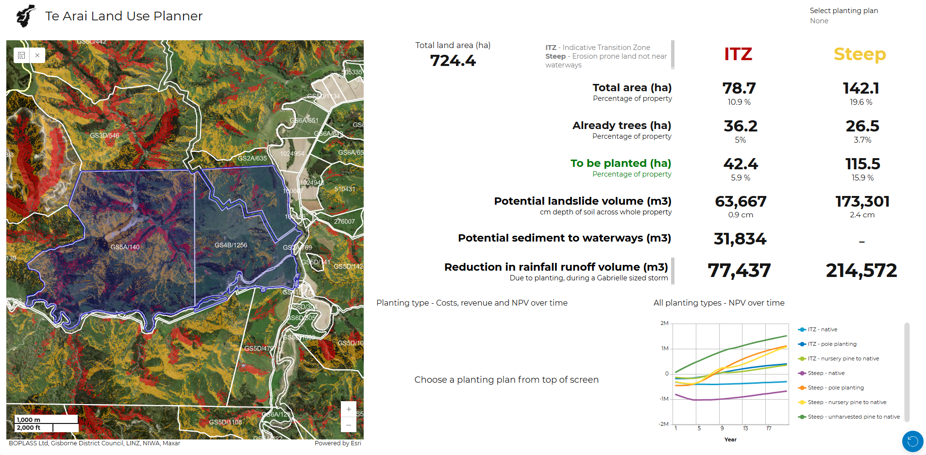
✅ Catchment-Specific Data – Unlike generic planning tools, this system is tailored to Te Arai. It includes local datasets, hydrological models, and cultural overlays to ensure decisions are grounded in place-based knowledge.
✅ Decision-Making Tools – Model land use scenarios, assess environmental risks, and explore the impact of proposed changes — all within a user-friendly interface designed for both professionals and community members.
How It was built
The development of the platform followed a collaborative, community-first approach including:
- Engagement: Local iwi, landowners, councils, and environmental groups were involved from the start through workshops, hui, and feedback sessions.
- Data Integration: The team worked to bring together diverse datasets — from satellite imagery and soil maps to water monitoring and planning documents.
- Design: The platform was built with usability in mind, ensuring accessibility across devices and technical skill levels.
- Testing: Beta versions were tested with real users, whose feedback helped refine the final product.
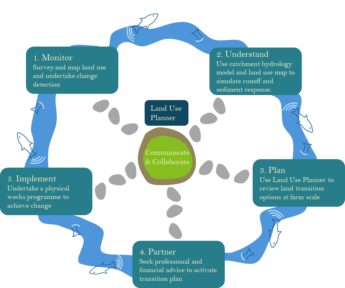
We have used a multi-stage catchment planning method consistent with NZ Landcare Trust.
Real-World Impact
- Since its launch, the platform has already begun to reshape how decisions are made in Te Arai:
- Planners are using it to guide development and conservation strategies.
- Landowners are exploring how their land fits into the wider catchment and making more sustainable choices.
- Community groups are using it to advocate for environmental protection and restoration.
- The system is helping to align individual actions with collective goals — fostering a more resilient and connected catchment.
Challenges and Lessons
- Building a tool of this scale wasn’t without its challenges:
- Data gaps required creative solutions and new monitoring efforts.
- Balancing simplicity with scientific depth was key to making the platform both powerful and accessible.
- Long-term sustainability is now a focus, with plans for ongoing updates and governance.
What’s Next?
The Te Arai system is designed to evolve. Future enhancements may include:
- Climate adaptation planning tools
- Expanded datasets on carbon sequestration and ecosystem services
- Mobile-friendly features for field use
- Replication in other catchments across Aotearoa
A Collective Achievement
This project is a testament to what’s possible when science, technology, and community values come together. It was a privilege to contribute to a vision that honours the land and empowers those who care for it. A huge thank you to everyone who helped bring this platform to life. We’re excited to see how it will shape a more sustainable and resilient future for Te Arai.